Google Maps
- GIS and Spatial Analysis
- GIS and Web Gis 2.0
The Geoblog of Citizens is an advanced Web GIS 2.0 Application which allows you to collect reports from local users, without registration in its current version. It, with demonstration purposes, experiments with great effectiveness the opportunity to acquire by the citizens thematic reports, and managing them with accessible GIS spatial features.
- GIS and Spatial Analysis
- GIS and Web Gis 2.0
A Geographical Information System for geocoded consultation of the Turistic Hotels’ data of the Province of Rimini, in the Emilia Romagna east cost (italy). This solution takes advantage of 'state of the art' procedures of batch geocoding and sophisticate techniques of wide territorial data and archives management and publishing.
- GIS and Spatial Analysis
- GIS and Web Gis 2.0
An innovative and shared Geographic Information System, developed according to Web 2.0 standards, as informative support to the creation of new Territorial Landscape Master Plan of the Puglia Region (http://paesaggio.regione.puglia.it/), for the formation of "shared knowledge" in the process of upgrading and enhancement of the Apulian territory. The Observatory is one of the first "Web GIS Application" created in Italy on Web 2.0 standards, with opensource tools (PHP, MySql, Javascript, Ajax, etc.) and enhanced interaction with users.
- GIS and Spatial Analysis
- GIS and Web Gis 2.0
A web 2.0 tool by which the regional government can know and make known the participatory processes active in its administrative boundaries. An advanced Web GIS with web 2.0 features, aimed at knowledge sharing and dissemination of best practices of eDemocracy processes in the Emilia Romagna Region.
- GIS and Spatial Analysis
- GIS and Web Gis 2.0
Web GIS-companies and local units of Emilia Romagna is a prototype experimental web that allows you to search and consult the main local units and the economic clusters in the territory of Emilia Romagna Region. The dataset has information related to the year 2005 and consists of more than 100,000 companies, with more than 3 employees. The system allows you to select and display cartographic companies individually and in clustered version in terms of sectors of activity (ISTAT) and overall employees.
Experimental prototype fully functional
- GIS and Spatial Analysis
- GIS and Web Gis 2.0
Web 2.0 GIS information system for the marketing of the main productive areas of the territory of Emilia-Romagna, candidates for Ecologically Equipped. An integral part of Regional Territorial Marketing site Invest in Emilia Romagna - Italy (www.investinemiliaromagna.it).
- GIS and Spatial Analysis
- GIS and Web Gis 2.0
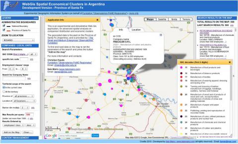
The Web-GIS Spatial Economical Clusters is an experimental web prototype that allows you to search, view and spatially analyze the main local units and the economic clusters in the territory of the province of Santa Fè (Argentina).


